Using the knowledge gained from the last time I set a more ambitious goal of also summitting all the peaks from Richthofen to Baker and getting as many ski descents in as possible.
We didn't have any car shuttle help, so had quite a bit of driving to do with 4 hours on Friday night and 5 hours on the return on Sunday night.
We started at the Crags trailhead at 4am on Saturday moving quickly to warm up. It was quite cold. I was wearing my micropuff under my helmet and had on windshells plus a hand warmer over my gloves. We had warmed up by the time we got past Agnes Cabin and we could start to see the moon losing some of its disk to the eclipse. Unfortunately we followed an existing skintrack in the dark and ended up on the flank of the wrong mountain(Braddock Peak). After breakfast burritos we realized our mistake and decided to ski traverse around staying as high as we could. Mark left his skins on and his splitboard in ski mode while I ripped and locked my heels. We skied through a number of large slide paths that had gone big within the past few years. One in particular felt almost like walking though burned out forests north of Steamboat Springs. It was eerie.

The snow was in great shape with 4-6 inches of fresh on top of a nice stable base and we had high expectations for our descent down Richthofen's SE face later in the morning.
We skinned up past Lake Agnes and made good time to Richthofen's shoulder. Amazingly the fresh snow made for easy skinning with no ski crampons required.

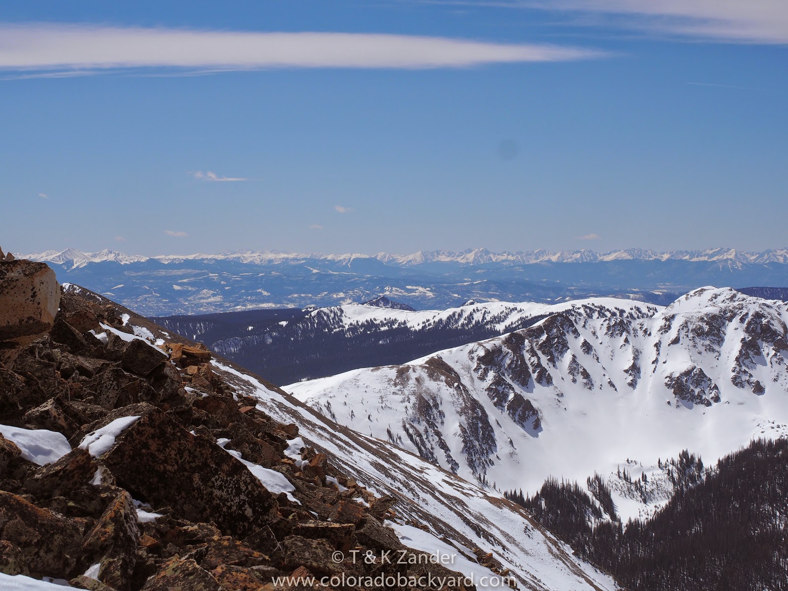
When we gained the ridge we were cold again with significant wind and while the sun was hitting Mahler Peak to the west of us, it would be awhile until we were blessed with its warmth. The hiking up the ridge was treacherous with the talus being loose and only covered with the most recent storm. It made slow and frustrating progress. When we got the view of our planned descent we were disappointed to find dry talus where there was plenty of snow on our last attempt. We started to climb down the talus to a ribbon of snow but that felt unsafe due to the steep pitch. I kicked off a large block and it kept bouncing past my view. So as soon as possible I put on my skis to sideslip the 'ribbon of death.' It is even more fitting here than early season at the resorts, and fall would have been very dangerous and the snow was narrow and very firm. I did manage a few turns in a small powder deposit before traversing hard right where we had made it down in 2013. I had to cross another talus field with fresh snow on top of dry rocks. This was possible by stepping with my skis, but I worried about how Mark, on a snowboard, would manage it. I managed to avoid any coreshots, but did definitely cause a little pain to my edges and bases with this maneuver. I kept traversing until I could see a line that I was reasonably sure would go. Due to the steepness and the fact that the slope rolls over I couldn't be certain that skiing down the snow I had just traversed would have gone, but in the future I would like to do a bottom up ski of this pitch because there are some very interesting lines to be had with the right beta. I skied down a narrow ramp with variable snow until I could see for sure that I would make it down and then turned my attention to Mark.


I called and hooted out to him for a few minutes with no response, but finally was able to see him. He was stuck on the talus traverse and justifiably freaked out. Eventually he made it through that and with some direction from me made it down safely. We had hoped to ski an enticing line off Teepee, but due to delays and being tired from the ordeal of the last ski we opted instead to get on with the traverse.


Getting to the saddle east of Lead was straightforward. I had hoped to summit Richthofen, Teepee and Lead, but we decided to skip the summit of Lead as well. We descended the gentle slope into the basin between Lead and Cirrus and decided to take a slope up Cirrus this time instead of traversing around into Lake of the Clouds. We were able to skin almost the entire way up the slope, only booting about the last 50 feet. From there I summited Cirrus and then we went across to Howard Mountain. We had camped at Lake of the Clouds in 2013, so I knew there were plenty of skiing options off the summit and the adjacent slopes, but the view from Cirrus was much more enlightening. There are so many options to choose from and I definitely plan on returning with the express goal of staying at Lake of the Clouds for a few days and skiing as much of Howard as possible.


From Howard we skied down in the general direction of Pinnacle Pool, but opted to stay about 400 feet higher in the basin. This gave us another hour or so of sunlight and the option to stay high and cross the ridge instead of traversing all the way around it, saving a fair bit of mileage in the morning.

We found a wonderful campsite that was flat, with great views and even a rock to sit on. I started to get the tent up and Mark made some great snow block walls for a windbreak. The sun was out for a few hours and we enjoyed the warmth and relative stillness. The night got off to a cold start and I was very glad to have the winter sleeping bag and a real tent fly rather than the tarp I brought last time. We slept well and decided to sleep in a little, letting the sun hit the tent before we got up.


We started off toward the saddle and Mark was feeling much better today. When we got to the saddle we discovered there was a large cornice blocking a steep and short descent into the basin. We weighed the options of skiing it, or just continuing up the ridge and taking a long ridge hike up Mt Cumulus. Eventually we decided to ski and and even though it was short, it was very aesthetic. We traversed as hard right as we could, even side stepping to get over a knoll and then transitioned to skinning with ski crampons. We were working our way up to the north east ridge of Cumulus via the southeast face below. There was a reasonable ramp and we managed to skin all the way to the ridge. From there we booted up a short section of easy ridge before putting the skis on and skinning to the summit. We were following some people tracks from recently, as well many mountain goat tracks with copious droppings and urine.


We decided to keep traversing the ridge toward Nimbus, leaving our skis and even skins on. I decided pretty quickly that it would be more efficient to just rip skins and lock my heels going down the ridge. We skied/side slipped to the low point and from there skinned again until we had to boot. It was a very easy ridge to traverse.


From the summit of Nimbus the ridge to Stratus is a little more rugged and we had to do a little down climbing 3rd class to get by. There were some very well formed cornices here.


From the summit of Stratus we left the ridge to avoid some significant rock challenges. I was getting pretty tired by this point and all the talus hiking with heavy packs was wearing on me. After a bit of route finding and getting a little confused about which line we were to ski we were at the saddle. The obvious line is very clear from above as it has the largest snow field at the top with a nice wide entrance. We left our packs here and continued up the short hike to the summit of Baker Peak. It felt great to have the pack off my back and after eating a bar I had plenty of energy to bag the summit quickly. We went back to our packs and started the descent. It was wide, pretty mellow and relatively consistent snow. Even so, I felt felt uncertain and made very tight turns down the whole pitch. I was jealous of Mark arching turns quickly down the line and waiting for me at the bottom.


We were able to ski out the drainage without much trouble, but once we got to the Grand Ditch we found the road to be almost completely dry. I was nervous that the remaining 5 miles out were going to be a checkerboard of isothermic snow and dry trail. We thought about hiking the Grand Ditch to where there is a road that does switchbacks down to the valley floor and we contacted park staff to ask about the trail(head) conditions. Ultimately we decided to hike half a mile or so further along the Grand Ditch to where a tongue of snow reached it and then skied into the Baker Gulch drainage. We bushwhacked for awhile before we finally found the trail. Once on the trail it was surprisingly in good condition. I left my heels locked and just herring boned or side stepped where needed(which was frequently as the trail was clearly designed for hiking.) We only had to take our skis off less than ten times and I was even able to skate the final flat stretch to the car!
Overall, I had a goal of standing on the summit of all the peaks from Richthofen to Baker, but we didn't get to summit Richthofen, Teepee or Lead. We did however, complete the ski traverse from Cameron Pass to the Bowen Baker Trailhead in RMNP while summiting the southern six peaks along the way.
According to my altimeter watch, the total elevation was 10,000 ft gained and 9950 ft lost. By recreating our actual route on Hillmap.com I find our total distance travelled to be 17.5 mi. Total distance driven(each) was 334 miles.
No comments:
Post a Comment